As Wisconsin sees warm weather, Gov. Tony Evers has declared an emergency over extreme fire danger in central and southern Wisconsin while parts of far northern Wisconsin are too wet and grappling with minor flooding.
“Protecting Wisconsinites from the destructive danger of wildfire is a top priority. Although northern Wisconsin still has considerable snow cover, the danger is extreme across much of the state today,” said Evers in a statement.
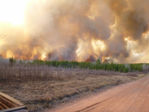
The Department of Natural Resources issued a red flag warning Wednesday for 41 counties that is in effect until 8 p.m. The elevated fire danger is brought on by warm weather, gusty winds, and dry conditions.
News with a little more humanity
WPR’s “Wisconsin Today” newsletter keeps you connected to the state you love without feeling overwhelmed. No paywall. No agenda. No corporate filter.
Evers’ order enables the DNR to quickly access and dispatch resources to keep fires at bay and minimize damage.
“This would include the Wisconsin National Guard Blackhawk helicopters with bucket capability. They are a call-as-needed resource, and they allow us to attack a fire and slow down the fire progression,” Catherine Koele, the DNR’s wildfire prevention specialist.
Those resources will help control fires for areas most in need this fire season, which typically lasts through May.
ALERT: Red Flag Warning issued for 41 Wisconsin counties for April 12, 2023.
Warm temperatures, low humidity, gusty winds and exceptionally dry fuels are anticipated and can result in catastrophic fires.
— Wisconsin DNR (@WDNR) April 12, 2023
The agency will continue to suspend permits issued for burning debris piles, burn barrels, and landscapes in affected counties. The DNR urges extreme caution with any activities that could lead to a fire.
“Campfires for warming or cooking, though they are not illegal today, we highly recommend that you hold off on those activities under these conditions,” Koele said.
The state experienced 133 fires that burned 330 acres at the same time last year. So far, the DNR has seen about 95 fires that burned 91 acres this year, of which 63 fires have occurred just in the last week. While the overall total is lower this year, Koele noted 2013 saw fewer fires when the Germann Road Fire burned nearly 7,500 acres across northern Wisconsin.
Northern Wisconsin is currently contending with another challenge due to extremely rapid snow melt over the weekend and last several days due warm weather.
In Douglas County, a stretch of State Highway 13 that runs along Lake Superior from County Road P to Port Wing had been closed briefly due to flooding. That area saw culvert failures and parts of the road washed away. However, Jason Jackman, the county’s highway commissioner, said there were no closures on state highways as of Wednesday afternoon.
Kevin Huyck, meteorologist with the National Weather Service office in Duluth, said one observer near Bayfield reported 50 inches of snow on the ground at the end of March. As of Monday, Huyck said a station there had 38 inches of snow on the ground and 13 inches of water in the snow pack. Just this morning, only 20 inches of snow remained with around 8.78 inches of water in the snow cover.
“The snow has been rapidly converted into liquid water, and then flowing downhill toward Lake Superior,” Huyck said.
The Nemadji River near South #Superior at 8AM for the last 4 days including this morning. Rivers and creeks will continue to be on the rise as the snowmelt accelerates #mnwx #wiwx pic.twitter.com/5TVgmYARgu
— NWS Duluth (@NWSduluth) April 11, 2023
Huyck said they’re most concerned about flooding in the northern portions of Douglas and Bayfield counties, noting a flood warning remains in effect there through Thursday afternoon.
Bayfield County Emergency Management Director Meagan Quarderer said rapid snow melt has led to flooding in the ditches that are undermining dirt roads. She said debris from a recent ice storm is also clogging culverts and causing water to back up in areas.
“Both the local town road crews and the county highway crews have been working pretty tirelessly to clear culverts and check the shoulders which are washing away,” Quarderer said.
While flooding is not yet severe, Quaderer said the county declared an emergency to preserve its ability to access financial assistance from the Wisconsin Disaster Fund, which reimburses local governments for damage.
In Ashland County, Huyck with the National Weather Service said they expect potential for major flooding on the Tyler Forks River as early as Thursday afternoon. Water from the river is expected to run over State Highway 169 between Mellen and Gurney, which Quarderer said has been closed. She added that U.S. Highway 63 is under a significant amount of water in the Bibon Swamp area of Bayfield County. Quaderer said the highway is still passable, but she also urged people not to drive over flooded roadways.
Huyck said levels on the Tyler Forks River should start rapidly coming down over the weekend. Minor flooding is expected near the mouth of the Bad River at Odanah by Thursday morning, but it’s not expected to crest over U.S. Highway 2. The National Weather Service has also issued a flood warning for the St. Croix River at Danbury in Burnett County.
The wet conditions are making it difficult for treatment plants in the region to handle the massive influx of water. In Washburn, the city has old sewer mains that may be cracked where water is seeping into pipes.
Scott Kluver, the city’s administrator, said its treatment plant typically processes about 200,000 gallons in a day. Now, the system has processed 1.6 million gallons over the last two days. When water exceeds capacity, it’s diverted into a storage basin that can hold 2.5 million gallons. That basin is currently full.
“The problem that we have is this has been happening now for several days, and we’re not getting a chance to process that extra flow,” Kluver said. “It just keeps building up. And if that basin overflows, that’s the part that would spill into the lake.”
Kluver said they’ll be monitoring capacity closely, noting the basin had not yet overflowed as of Wednesday afternoon.

Wisconsin Public Radio, © Copyright 2026, Board of Regents of the University of Wisconsin System and Wisconsin Educational Communications Board.