
Heavy rains and flooding will continue to threaten parts of southern Wisconsin through the middle of the week, according to National Weather Service forecasts.
The weather service has extended a flood warning for Madison until Thursday afternoon after the area received more than an inch and a half of rain Saturday night through Sunday evening. The weather service said another 2 inches of rain could fall through Wednesday.
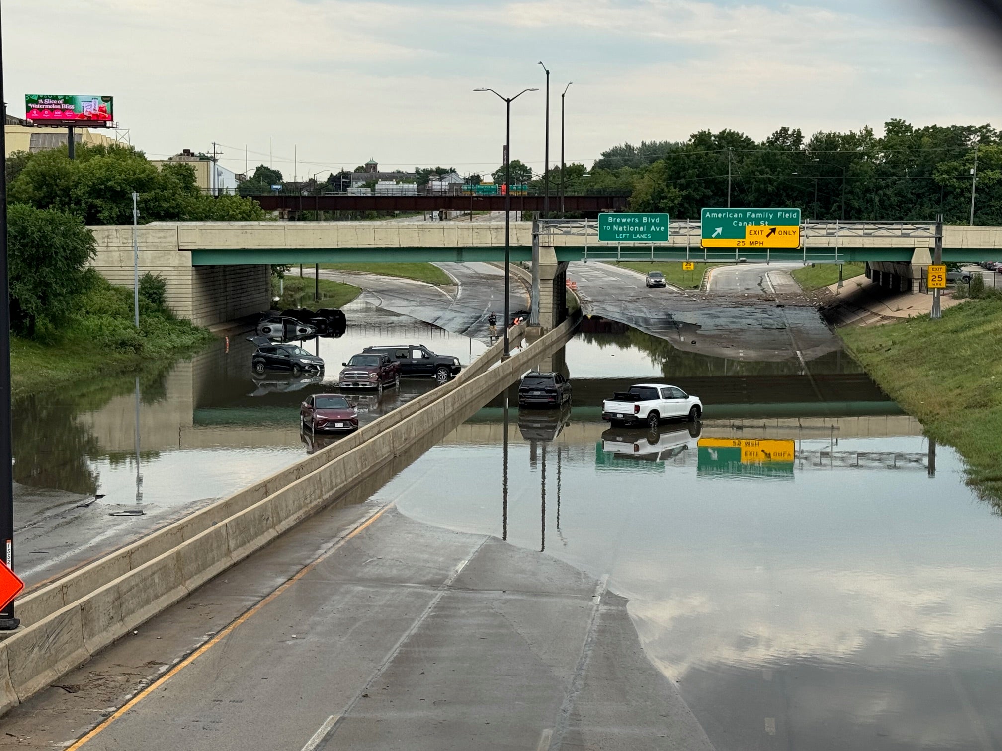
Water levels of the four Yahara River lakes continued to rise and Madison police say flash flooding has closed several roads.
News with a little more humanity
WPR’s “Wisconsin Today” newsletter keeps you connected to the state you love without feeling overwhelmed. No paywall. No agenda. No corporate filter.
City officials said that the water level on Lake Monona has reached a new record high and is currently at 7.5 inches above the 100-year flood elevation. Officials said they expect to release more water from the Tenney Dam either late Monday or sometime Tuesday morning. An increase in discharge rate from the dam may cause flooding, particularly on streets that drain to the Yahara River, such as East Washington Avenue, Livingston Street and other streets in the Tenney Park area.
Two more rounds of showers and storms this week: 1st into tonight and 2nd late Tue night/Wed. Locally heavy rainfall possible. #swiwx pic.twitter.com/M2Qvv8brsU
— NWS Milwaukee (@NWSMKX) September 3, 2018
Authorities say there is major flooding along the Baraboo River near Baraboo, Reedsburg and Rock Springs. Moderate flooding on the Fox River was reported near Berlin.
Wisconsin Emergency Management officials said that about 75 Wisconsin National Guard soldiers assisted the Wisconsin Department of Transportation on Sunday to place sandbags overnight along about a mile-long stretch of eastbound Interstate 90/94, near Wisconsin Highway 33 in Columbia County. They said they did so because rising floodwaters and more rain threaten to cover part of the highway and cause lane closures.
DOT officials tweeted Monday that they expect delays because of single-lane closures in place in both the southbound and northbound directions of Interstate 39, near Portage, in Columbia County. The lanes were closed because of water on the roadway. Officials are encouraging motorists to take alternate routes.
More Rain, Thunderstorms In Forecast
The forecast from the weather service’s La Crosse office said that rain will continue through Wednesday morning which could mean worsening flood conditions in some parts of the state.
More showers and storms tonight with heavy rainfall possible. This could lead to localized flooding in some areas. pic.twitter.com/QlsxuKswFl
— NWS La Crosse (@NWSLaCrosse) September 3, 2018
The weather service predicted that parts of southern Wisconsin will see showers and thunderstorms Monday afternoon through the evening.
On Tuesday, the forecast calls for more showers and thunderstorms in the morning and the evening.
#heavyRain continues likely Tue N-Wed morn for parts of the region. Flooding, river rises possible. Stay #weatherAware. #mwnx #iawx #wiwx pic.twitter.com/YTsbycz2YQ
— NWS La Crosse (@NWSLaCrosse) September 3, 2018
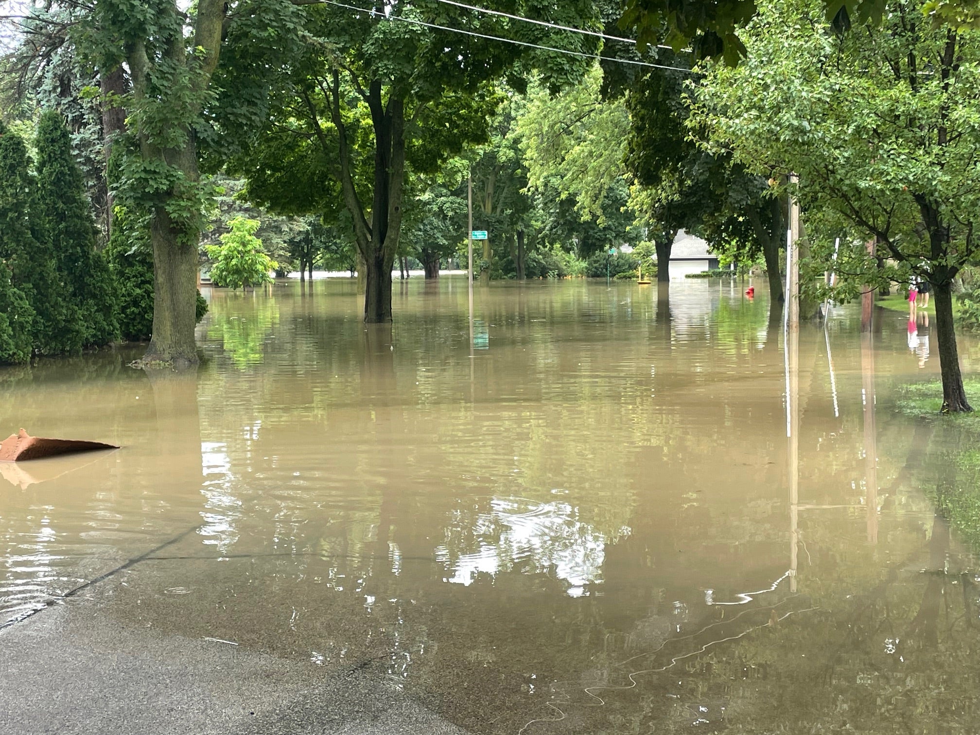
Storms have bombarded parts of Wisconsin from mid-August through this week, unleashing heavy rains and in some cases, tornadoes. In some locations, as much as 14 inches of rain have fallen, causing widespread flooding and leading to evacuations and road closures.
Much of the heaviest totals fell in the state’s southern half. The weather service said that while La Crosse and Appleton saw more than 6 inches of rain, other places received more than double those figures. Mauston got 13.84 inches, Port Washington saw 13.72 inches and West Bend received 12.35 inches. Madison got 9.79 inches and Viroqua got 8.87 inches.
Road Closures Continue In Madison
Residents of Madison’s east side and local officials are continuing to monitor the water levels in the city’s lakes.
More rain during the holiday weekend has resulted in some roadways being closed because of rising floodwaters.
City officials said Sunday night that the following roads were closed or partially closed:
- East Washington Avenue has one lane closed in each direction, but two lanes remain open in both directions. The right lane is closed on East Washington at North Livingston Street and at South Blount Street.
- North Livingston Street remains closed between East Washington Avenue and East Dayton Street. South Livingstone Street is closed south of East Washington because of construction.
- East Johnson Street is closed in both directions between North Baldwin Street and Fordem Avenue.
- Mifflin Street is closed between Blount and Paterson streets.
- East Main Street is closed from the Yahara River to Northern Court.
- North First Street has one lane open in each direction.
- Packers Avenue is now open.
Officials tweeted on Monday that they will continue to allow residents to park their vehicles in city garages for free overnight through Friday, Sept. 7. Parking is available from 9 p.m. to 7 a.m.
For more information about flooding in Madison, visit the city’s flooding information website.
Southern WI Rainfall: Recap and Forecast https://t.co/LriPkmzvpV pic.twitter.com/xsmyIE7uLQ
— NWS Milwaukee (@NWSMKX) September 3, 2018
Rains Threaten To Increase Flooding Near Rivers
The weather service has issued a flood warning for several rivers in Wisconsin, including the Baraboo, Fox, Crawfish, Milwaukee, Rock and Pecatonica rivers. The affected rivers include:
- Baraboo River at Rock Springs affecting Sauk County
- Baraboo River near Baraboo affecting Sauk County
- Fox River at Princeton affecting Green Lake County
- Fox River near Berlin affecting Green Lake County
- Milwaukee River near Cedarburg affecting Ozaukee County
- Rock River at Afton affecting Rock County
- Crawfish River at Milford affecting Jefferson County
- Rock River at Jefferson affecting Jefferson County
- Rock River near Lake Koshkonong affecting Jefferson and Rock counties
- Pecatonica River at Martintown affecting Green County
The weather service reported that the Baraboo River at Rock Spring was at 21.7 feet Monday morning and flood stage is 18.5 feet. Moderate flooding is happening and expected to continue. They expect it will continue to fall below flood stage by Wednesday morning. Near the city of Baraboo, the river was at 23.3 feet Monday morning and flood stage is 16 feet. Officials said that major flooding is occurring. They expect the river will fall below flood stage early Thursday morning.
The Rock River was reported to be at 9.6 feet Monday morning. Flood stage is 10 feet. The Pecatonica River at Martintown was at 10.9 feet Monday morning and flood stage is 13.5 feet.
Editor’s note: This story has been updated multiple times with new information.

Wisconsin Public Radio, © Copyright 2025, Board of Regents of the University of Wisconsin System and Wisconsin Educational Communications Board.