A commission representing Great Lakes tribes says the U.S. Geological Survey failed to consult with them before doing aerial surveys of mineral resources in northern Wisconsin, Michigan and Minnesota this spring.
The Voigt Intertribal Task Force that oversees off-reservation treaty rights opposes the surveys, and the Great Lakes Indian Fish and Wildlife Commission recently sent a letter outlining concerns that companies may use the surveys’ findings to identify minerals for mining.
That letter reads, in part:
Stay informed on the latest news
Sign up for WPR’s email newsletter.
“The Voigt Task Force has been and continues to be very concerned about the environmental impacts of metallic mineral mining, because those impacts translate directly into cultural impacts on tribes that use their reservations and the ceded territory for spiritual, cultural, medicinal, subsistence and economic purposes.”
GLIFWC executive administrator Jim Zorn said tribes want to know more and to be involved.
“I think the tribes are concerned that this is a way for the U.S. government to gather, let’s say for example, information on geological formations that would then just be a free-for-all for potential mining companies,” said Zorn.
USGS Midwest region director Carl Leon said the agency regrets the oversight of not involving are tribes.
“Right now, all the work on these two projects is on hold until we’ve contacted and engaged in meaningful conversations with the affected tribes,” said Leon.
Leon said no formal discussions would take place until tribes have a chance to review data collected from the surveys, which is still being compiled by the agency.
Federal policy requires tribal consultation on issues that may impact their treaty rights or communities.
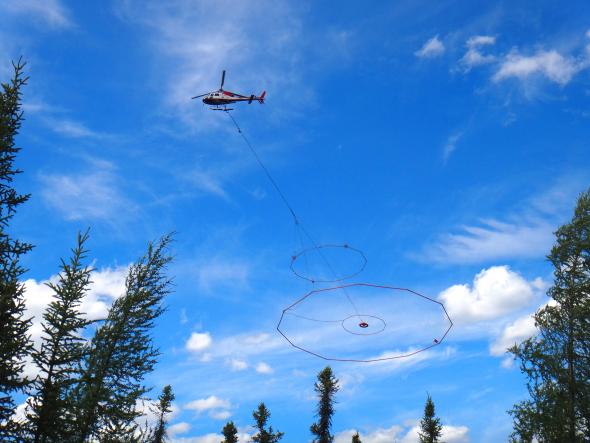
In April, the agency began researching geological terrain across the Midwest region. The data that was being collected to determine how the crustal layers were formed beneath the Earth’s surface. An aerial magnetic survey was being done to make maps showing the distribution of different rock types based on their magnetic properties. An aerial electromagnetic survey was completed on May 3 and sought to map variations in the electrical properties of rocks beneath the surface.
“While USGS does not conduct mineral exploration, the reports resulting from these surveys could be used by others to address land management issues, including the assessment of mineral resource potential,” said Leon.
GLIFWC’s Zorn hopes consultation will provide a better understanding of the surveys for their 11 member tribes.
“And what are tribal data needs,” said Zorn. “What can we or tribes do with their federal agency trustees to get the stuff that tribes can use and contribute to a truly good understanding of our natural world out there so we can preserve and protect it.”
The data that’s been collected so far has not yet been analyzed.
Wisconsin Public Radio, © Copyright 2024, Board of Regents of the University of Wisconsin System and Wisconsin Educational Communications Board.